Products You May Like
Get full access to Outside Learn, our online education hub featuring in-depth fitness, nutrition, and adventure courses and more than 2,000 instructional videos when you sign up for Outside+
Sign up for Outside+ today.
From our partners at Backpacker Magazine.
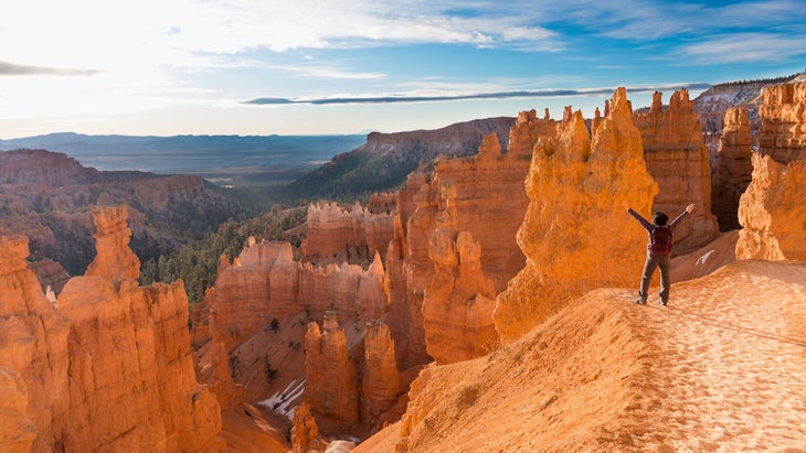
In the shadows of better-known Utah destinations like Zion and Canyonlands national parks, Bryce Canyon often gets overlooked. But skip it at your own peril: Bryce might be one of the nation’s smallest parks, but it features some of the country’s most astonishing geology. Best known for its glowing orange hoodoos, or spire-shaped rock features eroded by rain and ice, Bryce Canyon is also home to vibrant canyons and rare bristlecone pines. The best way to see all the wonder? Hoof it on one of these 12 perfect hikes.
Easy Hikes
Queen’s Garden and Navajo Loop Combination
Length: 2.9 miles
Elevation Gain: 646 feet
Trail Type: Loop
Difficulty: Easy
This is the most popular hike in Bryce, and it’s easy to see why. It looks out on the amphitheater from the rim before descending into the canyon. In just under 3 miles, you’ll pass notable park features like Wall Street, a narrow divide between two vivid orange cliffs, Two Bridges, a pair of natural arches, and the famous hoodoo Thor’s Hammer. This combination trail offers some of the most diverse scenery in the park, yet it’s relatively moderate, making it manageable to most hikers.
Sunset Point to Sunrise Point
Length: 1.1 miles
Elevation Gain: 82 feet
Trail Type: Out and back
Difficulty: Easy
If you want to avoid most of the Queen’s Garden and the Navajo Loop Combination hikers, you should hike from Sunset to Sunrise Point, a one-mile section of that popular hike. This out-and-back trail takes the average hiker about 25 minutes to complete, and it’s wheelchair-accessible and only has 50 feet of elevation gain. In this hike, check out some of Bryce’s most famous hoodoos and a full panorama of the amphitheater.
Bristlecone Loop
Length: 1 mile
Elevation Gain: 88 feet
Trail Type: Loop
Difficulty: Easy
Love strolling through the trees? This 1-mile loop is for you. Meander through subalpine forests of spruce, fir, and bristlecone pines. Living up to 1,800 years, bristlecones are the longest-lived trees on earth, and they often grow in twists and knots. Although it’s possible to find bristlecones in other parts of Bryce Canyon, this spot has by far the highest concentration of them. Plus, the trail stays above the rim, keeping hikers at an average elevation of about 9,000 feet—well out of the blistering desert heat.
Mossy Cave Turret Arch and Little Windows
Length: 1 mile
Elevation Gain: 118 feet
Trail Type: Out and back
Difficulty: Easy
In the desert, water is a precious commodity. That’s part of what makes the Mossy Cave such an unusual attraction. This trail offers dramatic views of nearby hoodoos while guiding you past a creek and to a waterfall. Water in this area makes it a great place to spot local wildlife like prairie dogs and mule deer, so don’t be surprised if you see creatures meandering about. In the winter, Mossy Cave is prone to freezing over, making for an otherworldly sight.
Tower Bridge
Length: 3.4 miles
Elevation Gain: 826 feet
Trail Type: Out and back
Difficulty: Easy
Natural bridges are one of the desert’s top features, and the Tower Bridge trail allows Bryce visitors to see one of the park’s best. Follow a trail for 3.4 miles before stumbling upon the Tower Bridge. Along the way, hikers will get great views of Boat Mesa (a flat feature that separates Fairyland Canyon from the rest of Bryce) and Sinking Ship (a wall of rock named for its resemblance to, you guessed it, a sinking ship). The Tower Bridge, the natural bridge that gives the trail its namesake, connects two massive pillars, just like the London landmark. It takes the average hiker just under 2 hours to complete this gratifying trek, starting from the trail near Sunrise Point.
Sheep Creek and Swamp Canyon Loop
Length: 4.5 miles
Elevation Gain: 647 feet
Trail Type: Loop
Difficulty: Easy
Even if it doesn’t get the same hordes as Zion, it can be somewhat challenging to escape from the crowds during Bryce’s busy season. Sheep Creek and Swamp Canyon allow you to do just that. In the spring, it’s one of the best places in the park to see wildflowers. The path descends into a ravine and guides hikers through a forest, then to Swamp Canyon via the Under the Rim trail, a wide ravine that has a collection of unique hoodoos.

Moderate Hikes
Peek-a-Boo Loop
Length: 5.2 miles
Elevation Gain: 1,500 feet
Trail Type: Loop
Difficulty: Moderate
Looking for a little bit of a physical challenge? Point your boots toward the Peek-A-Boo Loop. The 5.2-mile trail begins at Bryce Point, dropping into the canyon and passing hoodoos and the Wall of Windows, which is full of arches and cracks. Continuing on, you’ll pass views of tall, orange towers that emerge from the desert floor.
The Rim Trail
Length: 5.5 miles
Elevation Gain: 1,754 feet
Trail Type: Out and back
Difficulty: Moderate
You can’t take a trip to Bryce without catching a sunset or sunrise from the Rim Trail. This 5.5-mile hike takes about three to four hours to complete. It winds around the Bryce Amphitheater, which gives you fabulous views of the park’s hoodoos, which light up under the glow of the early morning or evening light like they’re on fire. Don’t put your camera away afterward: Hikers can expect more scenic overlooks as they make their way along the trail.
The Hat Shop
Length: 4 miles
Elevation Gain: 967 feet
Trail Type: Out and back
Difficulty: Moderate
The Hat Shop certainly has the weirdest name in the national park, and it’s one of the most unusual hikes too. The hike itself takes visitors through a section of the park that has a series of eroded pinnacles with boulders on top, making them look like little hats. Start your hike at the popular Bryce Point; it’s often less traveled than many of the park’s other trails, which can make it feel quite peaceful to harried visitors.
Bryce Amphitheater Traverse
Length: 4.95 miles
Elevation Gain: 1,053 feet
Trail Type: Out and back
Difficulty: Moderate
One way to hit a couple of the park’s best trails at once is by completing the Bryce Amphitheater Traverse. Over nearly 5 miles, the trail travels from Bryce Point onto Peek-A-Boo, connects to the Queen’s Garden, and then ascends to Sunrise Point. At the end of the hike, you can either catch a shuttle back to the start of the trail or hike an additional 3.2 miles to return to Bryce Point. The amphitheater offers spectacular views of Bryce Canyon, Peek-A-Boo, the Queen’s Garden, and Sunrise Point, where rows and rows of hoodoos stretch into the distance.

Difficult Hikes
Fairyland Loop
Length: 7.8 miles
Elevation Gain: 1,545 feet
Trail Type: Loop
Difficulty: Hard
The Fairyland Loop sets itself apart from other hikes because it provides otherworldly vistas on every step. It’s easy to picture mythological creatures here. Hiking this loop counterclockwise brings you through the “hoodoo graveyard.” As you continue on, you’ll wander past iconic spots, such as the Chinese Wall (which shows hoodoos at different states of erosion), Sinking Ship, and the Tower Bridges. Typically quieter and less popular than trails like Tower Bridge, this hike combines a rim hike with a more immersive canyon hike, allowing adventurers to explore Boat Mesa’s secrets while getting up close and personal with dozens of hoodoos. This hike is generally considered challenging, and it takes about four hours to complete. Please note that it also experiences a seasonal road closure, so make sure the trailhead is accessible before you attempt it.
Under-the-Rim Trail
Length: 22.4 miles one way
Elevation Gain: 4,366 feet
Trail Type: Point to point
Difficulty: Hard
Up for a challenge? The Under-the-Rim trail will turn your visit to Bryce into an epic dayhike or a moderate overnight trip. The easiest way to tackle this 22.4-mile hike is to begin at Rainbow Point and meander past rock spires, through pine trees, and across desert meadows before hitting the finish at Bryce Point. (Don’t want to do the whole out-and-back? Catch a shuttle back to halve your mileage.) It’s generally advisable to tackle this hike between June and September for optimal temperatures. Overnight camping requires a permit, which you can grab at the park’s visitor center.
