Products You May Like
When the snow starts to fall, the tourists start to retreat from the United States’ popular national parks, leaving just a trickle of visitors to enjoy them. But you know better: In winter, the national parks transform, finding a new kind of seasonal beauty. Make the most of it on these 9 fantastic hikes. —The Editors
Swamp Canyon Trail, Bryce Canyon National Park
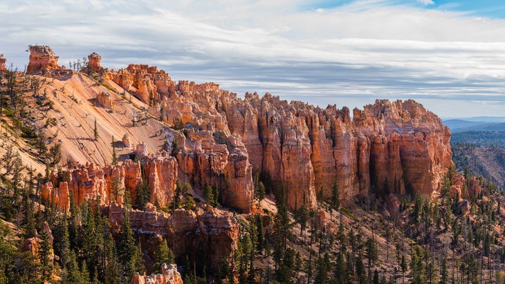
“The contrast of red rock, white snow, and blue sky leaves hikers speechless after an 800-foot climb to the Swamp Canyon overlook,” says Janice Stock, a Bryce Canyon NP spokesperson. Although not as dramatic as other viewpoints, swamp canyon is surrounded by fins and hoodoos that hikers can explore for peace and quiet. 4.3 miles; moderate.
Hike It: Swamp Canyon Trail
From the Swamp Canyon viewpoint, hike .1 mile to a T-intersection. Turn left onto the Sheep Creek Connecting Trail and follow it as it meanders through Ponderosa forests and the scars of old wildfires. At mile 1.3, the trail begins to descend, following Sheep Creek into the canyon bottom. Continue to the trail’s intersection with the Under The Rim Trail at mile 2.2, where you’ll take a right turn. At mile 3.4, continue straight onto the Swamp Canyon Connecting Trail and follow it back to where you started.
South Rim, Big Bend National Park
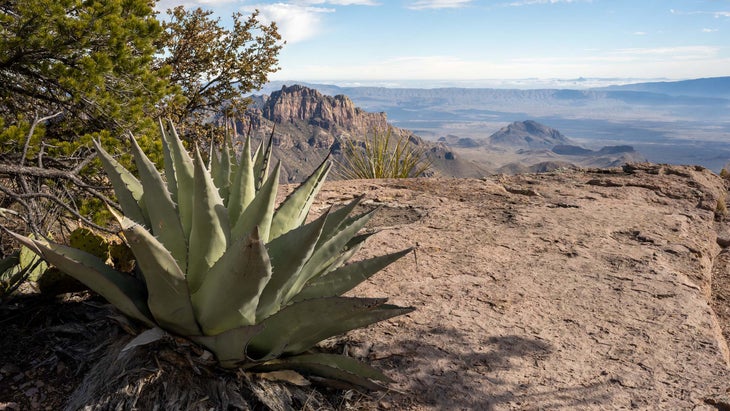
This trail can be deadly in the summer, since “temperatures run extremely high and the path lacks shade and water,” Claudia Arnberger of Big Bend National Park says. But it’s a perfectly pleasant overnight trip in the colder months. The climb spans cliffs, canyons, and plateaus over a 2,150-foot elevation gain and an incredible view of Sierra del Carmen and the Dead Horse Mountains. 12.3 miles; strenuous.
Hike It: South Rim
This hike is a leg-burner, gaining and then losing nearly 4,000 feet of elevation over its 12-mile length. It also has almost limitless variations, allowing you to put together the loop of your choice. Beginning at the Window Trail Trailhead, follow the path, making two lefts in quick succession after about 250 feet. At the .3 mile mark, take the left-hand fork onto the Pinnacles Trail and follow it as it climbs towards the canyon rim, bearing left at the intersection at .8 mile. After about 3.5 miles, the trail splits; continue straight or turn right onto the side trail to bag Emory Peak—the highest point in the Chisos Mountains at 7,825 feet—with a 2.8-mile out and back.
At mile 4.6, you’ll pass Boot Spring, an unreliable water source that can vary from a miniature waterfall to a damp mark on the rock. (Play it safe and haul your own water.) Just a tenth of a mile later, hike straight at the intersection with the Juniper Canyon Trail. (Spending the night? The South Rim 4 site sits at just about the halfway point at mile 6.3.) At mile 6.5, you’ll reach a viewpoint on the canyon rim; stop and feast on views of the park’s expansive, rugged desert. Continue following the South Rim Trail to the T-intersection at mile 8, where you’ll turn left onto the Laguna Meadow Trail and begin your gentle descent. At mile 12, continue straight to the parking lot to complete the loop.
Mirror Lake Trail, Yosemite National Park
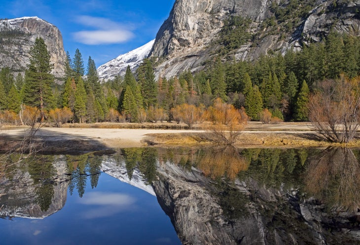
Winter doesn’t just bring spectacular scenery in Yosemite: It cuts down the summer crowds, letting you enjoy the park’s natural bounty without feeling like you’re jockeying for space. The Mirror Lake trail leads across multiple footbridges while snaking alongside Tenaya Creek. This trail tells the story of the “lake-to-meadow succession” of Mirror Lake through exhibits along the path and is open throughout winter except in the case of unusually heavy snowfall. 5 mile loop; easy
Hike It: Mirror Lake
This 5-mile loop gains only 100 feet on its loop around Mirror Lake, a definite plus in slick winter conditions. From the Mirror Lake Trailhead, take an immediate left. About .3 mile in, the path meets up with Tenaya Creek, which you’ll follow all the way to the lake. At mile 1, pass Lower Mirror Lake; almost immediately afterwards is larger Upper Mirror Lake, which in calm conditions reflects the iconic profiles of Tenaya Canyon’s cliffs. Starting at mile 1.2 there are side trails down to the water’s edge for those who want to wander; if you take that option, you’ll meet back up with the main trail at mile 1.9. Continue following Tenaya Creek until the loop curves back towards the trailhead 2.6 miles in. Stay straight at the junction with Snow Creek Trail at mile 2.9. Continue straight again at the junction at mile 3.8, then take the road back to Mirror Lake trailhead when you hit it 4.5 miles in.
Sand Bench Trail, Zion National Park
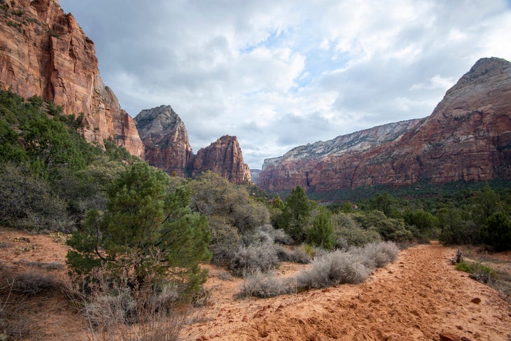
Used primarily by horses during the summer, this trail is great for hikers during the winter. It gains about 500 feet in elevation in order to reach a breathtaking view of the Court of Patriarchs. The sandy path makes it a slower hike, but it is one of the least-populated trails in all of Zion. Bonus: In the winter, mild-to-chilly temps mean you don’t need to sweat the heat. 3.9 miles; easy
Hike It: Sand Bench Trail
This desert loop high above the Virgin River has some of the park’s best views of the set of 2,000-foot redrock mountains known as the Court of the Patriarchs. From the Court of the Patriarchs trailhead, take a quick left just .1 mile in. Another .2 mile after that, go left again onto the Sand Bench Trail. Follow the main trail to mile 1.5, passing below the sheer cliffs of The Sentinel, a 7,120-foot mountain of Navajo sandstone. Continue another half mile to the Streaked Wall, a continuously overhanging rock face almost 2,000 feet high. From there the loop turns back towards the trailhead, looking out over the Virgin River Canyon. Close the lollipop section of the loop at mile 3.2, then retrace your steps to the trailhead.
Cadillac North Ridge Trail, Acadia National Park
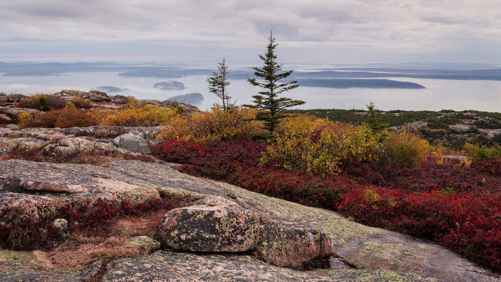
Cadillac Mountain is the first point to see the sunrise in the U.S. and remains largely accessible year-round despite frosty Maine temps. This trail is a prime spot to see snowy owls, Kathryn Grant of Acadia National Park says, adding that the contrast of snow-covered mountains against the blue ocean makes it even more striking during the winter months. Another plus: Chilly winter temperatures cut down on the mountain’s notorious crowds. 4.4. miles; moderate
Hike It: Cadillac Mountain via North Ridge Trail
Beginning at the Island Explorer bus stop, take the Kebo Ridge trail .1 mile, ascend a set of stone steps, and cross the road onto the North Ridge Trail and follow it as it ascends through a forest of red spruce, pine, and fir. At mile 1.3, the trail becomes steeper and the trees begin to peter out, giving way to granite slopes speckled with shrubs. Follow cairns and blue blazes uphill, turning right at a fork at mile 2.1, and finish the hike at the summit parking lot. Make the most of the spectacular views with a spin around the .5-mile Cadillac Summit Loop, then retrace your steps to the trailhead.
Wildrose Peak Trail, Death Valley National Park
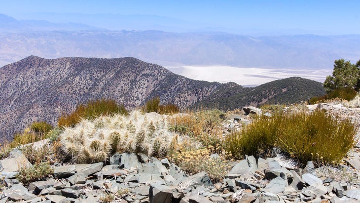
You don’t want any part of Death Valley in the summer, when temperatures can soar past 120 degrees and it’s occasionally to hot for rescue helicopters to fly, but the Wildrose Peak Trail is perfect for winter blues. The trail leads to incredible views as hikers ascend the highest section of the Panamint Mountains for a panorama featuring Mount Whitney and the Panamint Mountains. 8 miles; strenuous
Hike It: Wildrose Peak Trail
Begin at the trailhead near the Wildrose Charcoal Kilns, a set of beehive-shaped kilns created in 1877 to produce fuel for a set of lead-silver smelters about 25 miles away. Follow the trail 1.7 miles through classic pinyon-juniper forest to the top of a saddle. Keep following the trail another 2.75 miles, first over rolling hills and then up a set of steep switchbacks as you begin to climb the slopes of Wildrose Peak. At the top, take in the 360-degree views of the Panamint Range and the desert floor below, then turn around and follow the trail back the way you came.
Rowdy Bend Trail, Everglades National Park

Escape Florida’s balmy summers by visiting Everglades National Park during the dry season from December- April. Rowdy Bend Trail is optimal for woodland bird watching in the coastal prairie land and shady buttonwoods (keep an eye out for ospreys, which like to perch on vantage points on the trees here). This trail can be made into a longer 12.6-mile loop by combining it with the Snake Bight Trail. 5.2 miles; easy
Hike It: Rowdy Bend Trail
This trail follows an old road bed; it’s unmaintained due to the presence of endangered Cape Sable thoroughwort, a small blue flower endemic to the area, but is still open to hikers. Beginning at the trailhead on the Ingraham Highway, follow the trail as it winds through buttonwood groves and open coastal prairie. After 2.7 miles, the trail dead-ends at the Snake Bight Trail; head back the way you came or take a right and follow the trail a half-mile to a viewpoint that overlooks the water.
Porters Creek Trail, Great Smoky Mountains National Park
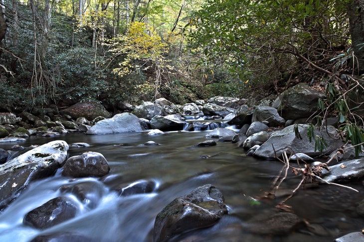
Great Smoky Mountains is the United States’ most popular national park, but go in winter and you won’t have to jockey for your spot. Reaching 2,600 feet in elevation, this trail remains fairly unaffected by road closures and winter snowstorms. Highlights include the Ownby Cemetery, an early 1900’s Smoky Mountain Hiking Club cabin and Fern Branch Falls, a beautiful 60-foot waterfall. 7.2 miles; moderate
Hike It: Porters Creek Trail
Starting at the Porters Creek Trailhead, follow the eponymous rocky creek on an old gravel road as the trail gradually climbs. Keep an eye out for low stone walls, which are all the remains of the Elbert Cantrell farmstead from the early 20th century. Shortly afterward, you’ll pass Ownby Cemetery, final resting places for a dozen locals. Just before the 1 mile mark, you’ll cross a footbridge, then take a left at the fork to stay on the Porters Creek Trail, then take another left at a second fork a few dozen feet later. At 1.6 miles, cross a second bridge and continue deeper into the woods, as old-growth trees begin to take over the landscape. Catch the waterfall at the 2 mile mark. Once you’ve gotten your fill, retrace your steps to the trailhead or continue another 1.7 miles to backcountry campsite 31 (reservations and permit required).
Fortynine Palms Trail, Joshua Tree National Park
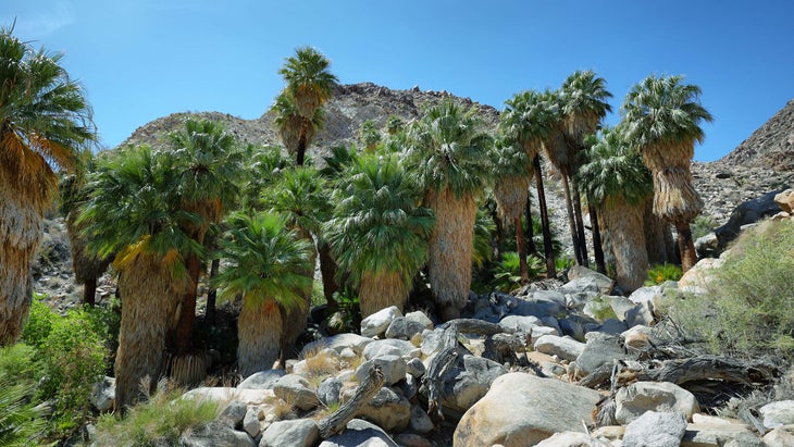
A short hike will take you into what feels like an entirely different world from the dry desert where you started. Hikers will enjoy the barrel cacti before descending into a rocky canyon where a palm-tree shaded oasis awaits. California’s benign winter climate offers perfect conditions for this normally scorching (and usually well-traveled) desert trek. 3 miles; moderate
Hike It: Fortynine Palms Trail
From the parking area, follow the trail up through prickly pear, barrel cactus, and creosote up to the top of a rocky ridge at .7 mile, where you’ll be able to take in a bird’s eye view of the town of Twentynine Palms. After dropping down into a valley, gain another ridge at approximately mile 2.2, then descend toward the oasis, a shaded retreat where a year-round water sources nourishes huge fan palms and clusters of reeds, providing a much-needed source of water for local wildlife. Retrace your steps to the trailhead.
While the summer crowds take the cold months off, you can cure your cabin fever by trying out these winter-friendly trails.
Don’t see a park near you on this list? Find more national park hikes here. Call up the ranger station and they’ll be happy to recommend trails that remain accessible year round.
Tips for Taking a Winter Hike in the National Parks
While you may not face the crowds that you would during high season, it still pays to plan ahead. Reserve any campsites as early as possible, especially for desert or southern parks that often become snowbird destinations during the winter. Check for seasonal closures when planning your trips, and in the weeks leading up to your departure, keep an eye open for weather-related trail closures. Not used to winter camping or hiking? There are some key differences to summer or shoulder-season trips; brush up before you leave.
