Products You May Like
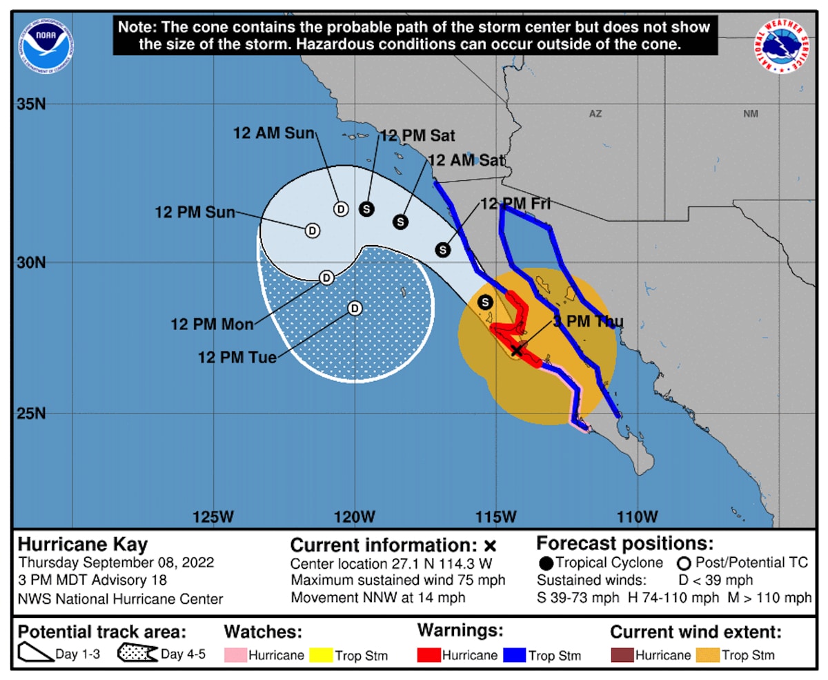
The predicted path of Hurricane Kay. National Hurricane Center
 Why you can trust us
Founded in 2005 as an Ohio-based environmental newspaper, EcoWatch is a digital platform dedicated to publishing quality, science-based content on environmental issues, causes, and solutions.
Hurricane Kay, which is currently churning off the coast of Baja California, could be the rare Northeast Pacific hurricane to impact the northern Mexican peninsula as well as drought-ravaged Southern California.
The storm could bring relief to a state baking under a record-breaking September heat wave, but heavy rainfall poses risks as well.
“[I]t’s never a good thing to get too much rain all at once, a trait all too common among slow-moving tropical storms, hence the enhanced flash flood potential,” the National Weather Service (NWS) Weather Prediction Center warned on Thursday.
It is unusual for Northeast Pacific hurricanes to reach Mexico’s Baja California, Yale Climate Connections said. And it’s equally unusual for them to have any impact on California. AccuWeather determined that the last tropical storm to get this close to Los Angeles was Hyacinth in 1972 while CNN said the last hurricane to come so close to Southern California was Nora in 1997. If predictions hold, Kay would be only the fifth storm since 1950 to remain at hurricane strength within 250 miles from San Diego.
Hurricane Kay was located about 110 miles off of Punta Eugenia, Mexico, as of 12 p.m. Mountain Time Thursday, according to a National Hurricane Center bulletin. Its center was expected to pass over or near Baja California’s west-central coast later today and near its northwest coast on Friday.
The major concern is rain. The storm could bring totals of six to 10 inches to Baja California through Saturday, two to four inches to northwest Mexico, two to four inches to Southern California and one to two inches to southwest Arizona.
“These rainfall amounts could lead to flash flooding, with landslides possible across mountainous areas of Mexico,” the National Hurricane Center said.
Maximum rainfall totals could be even higher in isolated areas.
For parts of Southern California, those rainfall totals would be more rain in two days than is normally seen in a year, CNN reported. For example, the Imperial County Airport in southeastern California normally receives 2.38 inches of rain a year. If the spot gets more than three inches of rain, this September would become its wettest on record. Both San Diego and Los Angeles could also see unusually wet Septembers, since they normally receive less than a quarter inch of rain during the month, according to AccuWeather.
“Despite the loss of wind intensity as Kay moves northward, the impacts to California will be notable,” AccuWeather Meteorologist Brandon Buckingham said.
Ultimately, the storm may help relieve the state’s ongoing high heat, drought and wildfires. However, at first the winds from Kay could increase temperatures, according to CNN.
“This happened in 1984 as a Category 1 Hurricane Marie well southwest of San Diego County forced temperatures to reach 100 in San Diego,” NWS San Diego meteorologist Brandt Maxwell told CNN.
Further, the winds could fan the flames of wildfires.
“Gusty winds could also fuel an elevated fire threat, based on how dry it has been across the region,” Buckingham told AccuWeather.
Temperatures should fall in Southern California late Friday.
The unusual storm comes as California has endured a summer of extreme weather events made more likely by the climate crisis. Storms, including hurricanes, tend to be wetter as global temperatures warm because warm air holds more moisture.
Subscribe to get exclusive updates in our daily newsletter!
By signing up, you agree to the Terms of Use and Privacy Policy & to receive electronic communications from EcoWatch Media Group, which may include marketing promotions, advertisements and sponsored content.
