Products You May Like
High above the gorgeous glacial lakes of the Big Pine Lakes basin sits a gem that will, one day, no longer exist. Surrounded on multiple sides by Eastern Sierra 14ers in California, Palisade Glacier wields a title no other glacier can: It’s the southernmost glacier in North America. But as glaciers around the world continue to melt at the hands of global warming, who knows how long that status will last?
That fleeting beauty is what attracted me to this hike. After spending three weeks exploring the vast glaciers of Alaska’s Last Frontier, I knew I had to see the Palisade Glacier while I still could.
It’s one of the most sought-out areas in the Eastern Sierra, so if you want to spent some time there, you have to plan ahead. You can dayhike Big Pine Lakes and Palisade Glacier with no problem, but to backpack, you have to secure permits. Luckily, I was going alone and stumbled upon the last backpacking permit remaining.

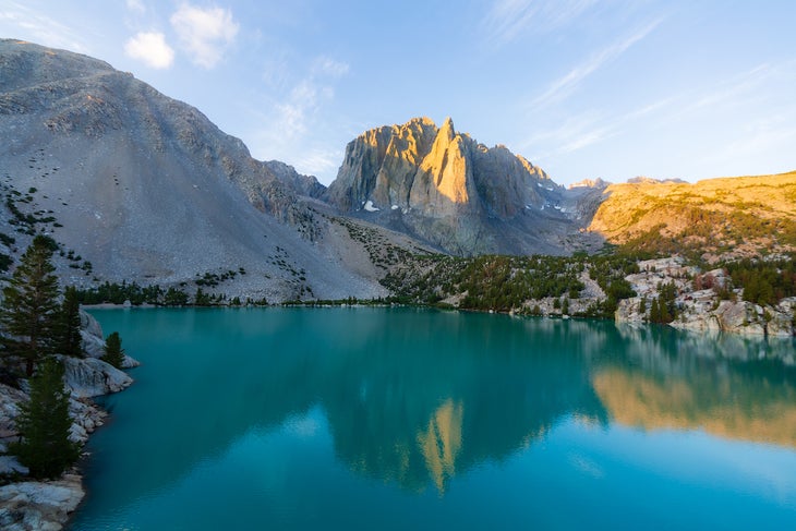
The trek up to Big Pine Lakes doesn’t have many technical sections. Starting at the parking lot, it’s a tad under 5 miles with 2,400 feet of elevation gain to Second Lake, which is worth a photo stop to say the least.
As with many hikes, you’ll want to start early. The first 2 miles are exposed (thanks to my midday start, I felt like I was baking in an oven). To get to Palisade Glacier, keep going past Second and Third lakes. Almost precisely at the 6-mile mark (1.5 miles past the main Second Lake photo spot), you’ll see a sign directing you toward the glacier. The first few miles are pretty straightforward. I was hoping it would continue that way as the ascent went on.
Thirty-five minutes later, I entered a miraculous glacier valley. It’s almost as if someone had taken a giant cheese knife and cut a chunk out of the rock. A milky blue stream ran through the valley, surrounded by green grass and flowers. I’ve been fortunate enough to see many gorgeous vistas in my life, but this moment was one I would think about long afterward. In an otherwise rocky and desolate zone, life was thriving.
A short uphill later, the trail ends and the Type 2 fun begins. In classic Eastern Sierra fashion, the trail becomes a boulder field, and hikers have to rely on their route-finding skills to get to the glacier’s 12,600-foot viewpoint. Roughly the final .8 miles are off-trail. Even though it’s not a long distance, it’s slow going as you make your way up, down, and around different natural obstacles.

The climb was exhausting. Though I’d slept the night before at 10,000 feet, my body constantly reminded me that I spend most of my time at sea level. As I reached 12,000 feet, I had to take more breaks, partly due to exhaustion and partly because I had to routefind my way to the glacier overlook.
But the views on the way up were glorious: While traversing the entire boulder field, I could see lakes one through three, shimmering in the most stunning blue-green I’d ever seen. With clouds darkening to the north, I reached the viewpoint, where I could see the glacier and glacial lake below.
As the clouds grew darker and thunder started echoing off the nearby rock walls, I began the trek down, taking one last look at a glacier I’ll likely never see again.
I’m not alone in turning my back to glaciers. The world does it every day, as we fail to reverse the cumulative effect of growing levels of carbon dioxide in our atmosphere. As a result, glaciers worldwide continue to dwindle until they are simply a yearly snowfield. When Palisade Glacier’s run ends, there will be a new southernmost glacier. And when that one melts, a new one after that. I now look back at my photos, knowing that one day, they’ll likely join the black-and-white ones we now use to remember all the world’s vanished ice.
Hike It
Permits: Not needed for dayhikes. Only needed for backpacking or camping trips. Find overnight permits for Big Pine Creek North Fork here.
Length: 16 miles roundtrip to the glacier overlook, 10 to the classic second lake photo spot
Elevation Gain: 4,800 feet to the glacier viewpoint
