
Products You May Like
For eons, sailors have used the position of stars, constellations, and other celestial bodies to help them pinpoint their position on the surface of the Earth. Putting sextant to eye and carefully reading wind, tide, and current, generations of wayfarers have navigated myriad passageways to new lands.
But the mid 20th–century Cold War space race took the idea of using celestial bodies to guide our paths to new heights. On October 4, 1957, the Soviet Union launched the first human-made satellite, Sputnik 1, into space. It orbited the earth, transmitting data back to a laboratory in Russia for three weeks before it ran out of battery power. It remained in space for a total of 96 days before finally falling back toward the earth and burning up on reentry.
Though Sputnik didn’t last, one discovery did: Researchers at the Applied Physics Laboratory at Johns Hopkins University noticed that as the satellite got closer, the radio signal frequency transmitted by Sputnik increased. As the satellite sped away, the frequency slowed. This change, known as the Doppler effect, meant the satellite could be tracked from the ground.
At the time, this technology was best suited for military applications. The U.S. Navy was keen to have this sort of capability, as it could be used to help guide ships, submarines, and the missiles they launched. Few, if any, people imagined this new Global Positioning System, or GPS, would ever evolve to a personal tracker, much less one that would become an essential tool for runners and cyclists.
Today, it’s rare to see an endurance athlete who doesn’t train with some kind of GPS device on their wrist. Smartwatches and fitness trackers are all but essential for the athlete who wants to collect every crumb of data from their workouts: where they ran, how far they went, and how fast they covered the distance. GPS records all of this data so seamlessly, that it’s easy to take for granted the intricate cosmic efforts required to make it happen.
No Longer Lost in Space
Since Sputnik’s chatty transmissions revealed that objects could be precisely tracked anywhere around the globe from space, using satellite-based technology to understand location has become a truly global industry. GPS, which refers to a dedicated set of satellites owned by the U.S. government and operated by the U.S. Space Force, is just one system under the collective term Global Navigation Satellite Systems or GNSS. China operates a 35-satellite system called BeiDou (BDS). Europe has a 24-satellite system called Galileo. Russia owns and operates GLONASS, short for Globalnaya Navigazionnaya Sputnikovaya Sistema. Japan and India have smaller systems.
Across all these satellite constellations, collaboration and cooperation is key; a variety of international agreements are in place that permit the various systems to work together in space, no matter what geopolitical strife might be transpiring on the surface of the earth. Some civilian devices leverage multiple systems to provide more accurate positioning data.
And to crunch that data into something a civilian can use requires a lot of complex mathematics. Whether you’re asking Siri to give you directions to the store or using a smartwatch to log your cycling mileage, there’s endless streams of computer code that make it all work. But in simpler terms: A chip in the device receives a broadcast signal from satellites overhead to determine where and when you are in space. Then, using intricate calculations that compute latitude, longitude, altitude, and time, your GPS device can tell you where you are, where you’re going, how fast you’re moving, and many other important pieces of information.
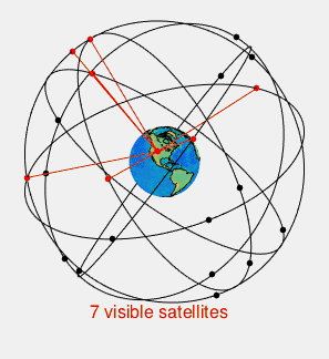
GPS-enabled devices need to connect with at least four satellites at once to work properly, and depending on where you are, that can create some challenges to getting an accurate read.
The Challenges of Tracking Your Activities
Garmin International is perhaps the best-known maker of consumer GPS products. Founded in 1989, the company makes many devices that leverage GPS, from navigation systems for airplanes and boats to watches for athletes.
Joe Heikes, Garmin’s consumer segment product manager who works primarily on the company’s Forerunner watches, said that when it comes to tracking swimming, biking, and running activities accurately, “the fundamental technology is the same for all three sports.”
The watch receives a signal from several satellites at the same time and works on a principle called “trilateration,” which measures the distances between those four or more satellites to determine where the receiver device is located on Earth. “Typically, we’re tracking a lot more than four satellites,” Heikes said, but that’s the minimum needed to gain an accurate location result.
Of the three disciplines, “swimming, as you probably would guess is the hardest” to track accurately, Heikes said, because when the watch is underwater “it can’t hear the satellites.” The signal can’t penetrate the surface of the water. When swimming freestyle, your arm is underwater roughly half the time, so depending on the frequency of signal reception from passing satellites, you might end up with a funny looking path of travel.
The reflective properties of water can also cause the signal to bounce when transmitting on or near water, which can further complicate aquatic measurements. “And then if the athlete switches over to breaststroke partway through to take a break, which a lot of people do, then we’re blind” because the watch is fully submerged. “We really have no idea [where the athlete is] until that watch comes back out of the water.”
The advanced calculations that back these highly calibrated devices, however, are designed to cope with such uncertainty and your device likely is quite good at filling in gaps that arise during swimming sessions to offer up a mostly accurate swim course.
Running tends to be a little simpler to calculate because it’s all happening on land. But there can be some challenges there too, Heikes said. “When your arm is swinging back and forth rhythmically as you run, it can be difficult for the watch to decode,” especially if one satellite slips over the horizon and a new one comes into view that the watch must establish a new connection with.
If you’re running through a thickly wooded area, that foliage can obstruct a clear signal. Tall buildings in densely populated urban areas can also interfere with clear signaling between your GPS device and the satellites it talks to. GPS devices “work better out on the wide-open prairie of Kansas than they do in downtown Chicago. It’s just the way it is,” he said.
However, most GPS devices designed to track running have algorithmic workarounds programmed in to reduce such issues. Frequent updates to the operating software and map data sent to the device continue to refine accuracy with everything from pace to elevation gain.
The good news is that when you hop on your bike you can be confident that the resulting GPS track is going to be pretty darn accurate. “Cycling is by far the easiest” to track, said Heikes, because endurance cycling efforts typically take place on roadways that have clear access to open sky and the watch or computer is fairly stationary in relation to the bike (i.e., not swinging back and forth). “That’s usually a pretty good scenario for us getting good satellite tracking,” Heikes explains.
Some of Garmin’s higher-end Fenix watches have the ability to connect with satellites in the GPS, GLOSNASS, and Galileo systems, which increases their accuracy—the more information the watch has to work with, the better the accuracy of its positioning capabilities.
Building a Better Sport for Endurance Athletes
Today, GPS powers a vast number of devices, apps, and tools, many of which are key components of endurance athletes’ gearboxes.
For example, many athletes today love to post all their workouts on Strava, a social platform for sports and fitness enthusiasts that launched in 2009. Varun Pemmaraju, Strava’s senior geo engineer and “sometimes triathlete,” said more than 99 million athletes in 195 countries around the world use Strava.
What makes Strava, a Swedish word that means strive, so popular is its segments—stretches of trail or road that athletes can compete on against each other or themselves. Pemmaraju said this community-based input has developed into a leaderboard that has grown over time “as more people pushed themselves up their local hill or took a crack at their neighborhood loop. There are now 30 million segments across the world and over 100 billion unique efforts on those Segments,” he said.
To make it all work, “devices connected to Strava will send us what we call ‘points,’” Pemmaraju said. These points may include latitude-longitude location, heart rate, speed, power, and any number of other data pieces recorded at each second over the course of an activity. “Sometimes that data is accurate and precise, but often, as many of us have experienced, the GPS trace can be all over the place,” he said. “It’s our job to make sense of those traces.”
Ride with GPS is a cycling-specific platform that’s similar in some ways to Strava, but offers some special options for riders looking for support on long journeys. Kevin Prentice, marketing director, said that one of Ride with GPS’s key features is the ability to plan your ride before you head out. Users are able to download maps and turn-by-turn navigation cues that function just fine even when your phone is in airplane mode—essentially cutting out the digital middleman and potential blind spots along the road. “You’re not going to lose fidelity since you’ve downloaded all the associated tiles with that route to your phone,” he said. Working offline can also help save on battery power.
Ride with GPS also allows users to geotag and timestamp photos they take along the way, creating a sort of photo-enhanced blog of the route. These can be shared with select contacts—friends who might want to duplicate your route or loved ones who want to keep an eye on your progress as you go. Followers can leave comments in real time that can be read aloud to you as you cycle if you need some motivation. All of these features have made the product very popular with weekend warriors and bike tour companies alike.
The Future of GPS Smartwatches for Athletes
Longer battery life
As Prentice noted, being able to shut off cellular capacity on your device can help prolong battery life, which is often a point of pain for endurance athletes who use such devices. The longer the sweat session, the more likely that your faithful tracking device will conk out.
That makes improving battery life perhaps the most immediate technological advance that consumers are clamoring for in their GPS devices. As the science of battery-life extension grows by leaps and bounds (thanks, Tesla?) not having to recharge your watch every single day is a dream within reach for some devices, such as the line of endurance running–focused wearables from COROS.
Dan Suher, director of global sales and marketing with COROS, said that extra-long battery life—35 to 40 hours of GPS tracking to be precise—is a key differentiator from other GPS-enabled devices on the market.
Depending on which device and how you use it, “you can go anywhere from 10 days to well over a month between charges,” he said. Some of the higher-end models have up to 140 hours of GPS battery life, which is great if your adventures take you over the hills and far away, well beyond the reach of an outlet and extension cord.
COROS achieves this extreme battery life by emphasizing performance metrics first, lifestyle features second. Many fitness tracking devices these days are essentially smartwatches with some added GPS-tracking capabilities. But COROS’s watches “don’t do much of that,” Suher said. The watch will notify the wearer of incoming texts and calls, but “I can’t pick it up and do the Inspector-Gadget-talk-on-my-watch thing.” Removing those features puts less pressure on battery life, which means there’s a lot more capacity to track those really long hikes and ultra-long runs.
COROS has deliberately chosen to concentrate on sports tracking performance rather than lifestyle features, and other companies are likely to pick a side for the type of athlete they want to cater to. More stratification across the market could be coming.
Enhanced tracking and safety features
For the companies that opt to provide more smartwatch-style capabilities, enhanced health tracking information—think sleep, heart rate, blood sugar, and other bio-data monitoring—are likely to continue evolving. Some devices do a better job of tracking such details currently, but expect to see improvements across the board as the various components that go into these increasingly petite devices become ever more sophisticated.
Improved safety may also be coming soon to a GPS-enabled device near you. Stephanie Schulz, senior public relations specialist with Garmin, said that GPS-enabled safety features are increasingly becoming a marketing tool for fitness and sports watches that are aiming to help users stay safe on the trails. Garmin’s version is a little like the OnStar feature found in some cars, but it’s on your wrist every time you head out the door, offering peace of mind for some athletes.
“As a female runner who runs alone, just knowing that I can have incident detection or assistance features with the press of a button to alert my chosen contacts to the exact location where I am should anything happen—I think that’s just incredible to have,” Schulz said.
Fair racing
GPS may even be the key to making triathlon a fairer sport.
The new RaceRanger promises to end the scourge of drafting in triathlon, said James Elvery, a former pro triathlete and co-founder and CEO of New Zealand–based Precision Triathlon Systems, which is developing the RaceRanger.
Elvery said the device, which is about the size and shape of a hockey puck but quite light, leverages GPS signals alongside another technology that does better in tighter quarters called ultra-wideband. UWB is a type of radio signal that measures the distance between two devices. (It’s also what’s used in Apple AirTags that helps you find your keys.)
The RaceRanger uses GPS “as a guess-timation of roughly where people are from quite a long way away. And then once they get to the range that we really want to know about [i.e., are they drafting?] we flick over to the ultra-wideband,” Elvery said. If a rider is following too closely, a signal goes out to the race referee’s device alerting them to the violation. The device also lights up so that riders can police themselves and back off if they start drafting.
“Right now, you can fool yourself into thinking, ‘yeah, I’m not really drafting, or maybe I am a little, but I’m not as close as some others.’ Whereas with RaceRanger you will know if you are or not. You’re in or you’re out,” Elvery said. “And you really don’t want to end up on the referees’ worst offenders list because they’re going to be targeting those people” to hand out penalties.
This innovative use of GPS alongside ultra-wideband could open the door to other positional innovations in the sport of triathlon. At the very least, Elvery said, “we hope it’ll change people’s behavior.” Not just because it’s not fair for an athlete to cop a free ride, but also “if you’re at least separated out by two or three meters, it’s a lot less dangerous.”
RaceRanger will undergo real-world testing at several triathlons in the U.S. and Europe this spring, and depending on how it goes, Elvery said it could become a standard tool at major triathlons around the globe in the near future.
Written in the Stars
GPS technology has come a long way from its star-tracking origins. Even one of the original mathematicians who worked on the technology, didn’t know her calculations would be used in a product that would one day be on the wrist of many endurance athletes.
Dr. Gladys West, a mathematician with the Naval Proving Ground (now called the Naval Surface Warfare Center, in Dahlgren, Virginia), developed a mathematically accurate model of the Earth’s exact shape that became the basis for the Global Positioning System. In some senses, she’s the “Hidden Figure” of GPS, as her story only came to light recently, after the release of the 2016 movie of the same name that told the story of three other brilliant Black female mathematicians who had a big impact on NASA’s trajectory but didn’t get credit until recently. But even as she worked on the project, she didn’t know exactly how it would be used, only that it was highly secretive and had implications for defense. Just 10 years ago, when her daughter gifted her a Garmin GPS device, they hadn’t realized the connection between West’s work and the gadget that offered turn-by-turn navigation to anywhere she wanted to go.
West’s integral status to this now-ubiquitous technology only came to light when she sent a short autobiography of herself for an alumni sorority function. Her sorority sisters immediately recognized that West’s work had likely been far more impactful than West realized. In 2018, West was formally recognized by the Virginia General Assembly for her contribution to the development of GPS. She was inducted into the Air Force Space and Missile Pioneers Hall of Fame the same year.
West told The Guardian in 2020, “you never think that anything you are doing militarily is going to be that exciting. We never thought about it being transferred to civilian life, so that was a pleasant surprise.”
RELATED: