Products You May Like
Heading out the door? Read this article on the new Outside+ app available now on iOS devices for members!
Download the app.
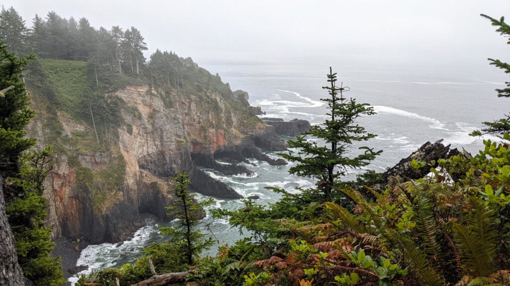
In profile, the tip of Cape Falcon looks like a long, crooked finger dipping into the Pacific. From the coastal rainforest 200 feet above, it slopes down to sea level, hemlock and spruce giving way first to ferns and gnarled salal, then to sheer, banded sandstone cliffs that drop straight into the roiling surf.
Perched on a nearby lookout, I peered down at the waves below and instinctively tightened my grip on my 3-year-old son Rhys’s jacket. We were less than two hours into a 13-mile hike through the Oswald West State Park section of the Oregon Coast Trail, and for the sixth or seventh time we had stopped to take in the view. But how could we just walk on by this?
This is the hiker’s dilemma on the Oregon Coast Trail: There are 425 miles to cover, and so many sights to stop and see along the way that, if you’re not careful, you might never get to the finish line. At its best, the OCT is like a hiking Greatest Hits album, a series of soaring clifftop vistas, towering forests, and wild Pacific beaches stitched end to end. A day or a weekend on it is a sampler of everything captivating about the Pacific Northwest. An end-to-end thru-hike? As long as you can handle some pavement-pounding—the trail still has its gaps—it’s the kind of adventure you won’t be able to replicate anywhere else.
The sun still hadn’t risen when my wife dropped us at a pullout off of US 101 to begin our hike south. It was slow going at first: Under the rainforest’s canopy, the October morning gloom condensed into inky blackness. A hundred feet from the trailhead I snagged my foot on a tangle of roots and nearly went down, catching myself on my trekking poles before I pitched onto my face. As the first hints of daylight began to filter through the foliage and fog, we picked our way south and west, heading toward the sound of the sea.
Before it’s anything else, hiking the Oregon Coast Trail is a sonic experience. As you walk away from 101, the federal highway that traces the length of Oregon’s coast, the rumble of trucks and traffic recedes; approaching the coast, you hear the crash of waves breaking against rock before you smell the salt spray or see the water. In between, the rainforest blankets everything in a thick, heavy quiet, the pine needles and humus muting even your footfalls. Paradoxically, with outside sounds turned down, the natural noises of the forest only stand out more. Each bird call, creaking branch, and drip of water is audible against the silence.
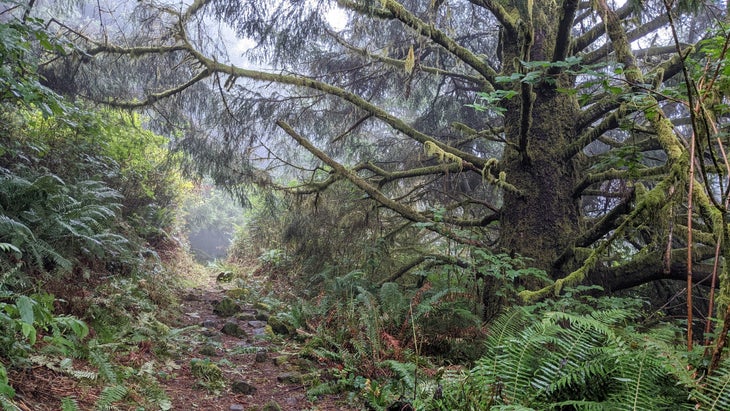
If you’re used to lesser woods, the sheer density of Oregon’s old-growth rainforest is shocking. Sitka spruces and Douglas firs interweave their canopies with beards of lichen hanging off their branches and turkey tail and reishi mushrooms jutting from their trunks like shelves. Ferns and skunk cabbage sprout between them in the wet duff. Moss coats everything from living trees and punky deadfall to signposts and the ground itself. By some estimates, this and other temperate rainforests of the Pacific Northwest are the most concentrated collection of plant life in the world, with a biomass several times higher than that of a tropical forest.
That these temperate rainforests are so dense is partially due to wildfires—specifically a lack of them. Unlike the drier forests of central Oregon or California, large-scale blazes are rare here, thanks in part to the more than 100 inches of rainfall that the wettest parts of Oregon’s coastal rainforests receive annually. (It bears mentioning that the rainforest can still burn during unusually dry summers, which many researchers expect will become more and more common as the Earth’s climate warms.) In recent years, that has made the OCT a fallback for Pacific Crest Trail hikers forced off-route by megafires, as many were in 2022.
Even when it’s not raining, the moisture on the coast seems ambient, thickening the air and coalescing into dense fog banks. As we hiked, every bush and branch we pushed past sprinkled us with dew. Within an hour, my clothing was damp enough that it clung to my skin.
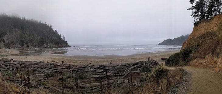
Despite the temptation to stop and snap photos every 100 yards, we made decent time. Rhys alternately rambled down the trail, pausing to pick up toddler-size walking sticks-slash-pirate-swords, and rode on my back in a soft carrier I had brought. By 10:30 a.m. we had reached our planned lunch spot at Short Sand Beach, a hike-in-only half-mile stretch of coast bounded at one end by a waterfall and the other by forest-topped sea cliffs. We ate ramen we cold-soaked in a Nalgene; Rhys built a sand castle ornamented with driftwood and smooth cobblestones while I squished the damp sand between my toes and watched a half-dozen wetsuited surfers catch waist-high waves backdropped by a wall of sea fog. For somewhere just more than a half-mile from the nearest parking lot, the beach felt oddly remote, like we had found a place on the edge of everything.
If it weren’t for the way Oregon has preserved its beaches, it’s fair to say the OCT wouldn’t exist. Nearly 40 percent of the trail is beach walking, long rambles down public stretches of sand. The fact that those beaches are open to hikers at all largely comes down to two bold moves that the state government made a half-century apart.
The first occurred in 1913, when, in response to private sales of beach property, Governor Oswald West and the state’s legislature declared the entire shoreline of Oregon a public highway. That same year, they established the Oregon State Highway Commission. Beginning in 1922, the Commission created Oregon’s first state park from donated land, founding what would soon become a string of recreation areas down the coast. Ten years later, it completed work on what is now US 101, the highway that traces the path of the OCT today.
But there was a catch to those protections: They only applied below the high tide line. In 1966, Bill Hay, the owner of the Surfsand Motel in Cannon Beach, took advantage of that loophole, using logs to fence in a section of beach for guest use only and posting “no trespassing” signs around it. In response, the state legislature introduced the Oregon Beach Bill, which declared all of the state’s beaches, from the vegetation to the water, public.
At first opposition to the measure was stiff; conservative legislators rebuked it as government infringement of property rights. But the bill had a powerful supporter in Tom McCall, the state’s Republican governor, and after he successfully rallied public opinion with a high-profile appearance in front of the Surfsand’s disputed plot of beach, the state’s legislature passed it near-unanimously in June 1967. As a result, Oregon’s entire coast is open to the public, with little of the ambiguity, carve-outs, or legal dodges that have locked up sandy shores in other parts of the country. If there’s a beach in Oregon, you can hike on it.
I think this is as it should be. Spend a few hours walking the OCT, and you’ll come to appreciate my point of view. The coast here is sculpted, with sea stacks and cauldrons and little pocket beaches carved into the rock by the distal edge of a sea that stretches clear to Japan. The idea that someone rich or fortunate enough could stamp “mine” on all that beauty and keep the rest of us out would be laughable if it weren’t so offensive.
With our break over, we got back to hiking. Before long, we had crossed 101 and started the steep ascent up Neahkahnie Mountain, the high point of the trail at just over 1,400 feet. We switchbacked through meadows blanketed in fog, Rhys riding in the soft carrier on my back while I gritted my teeth and plodded up.
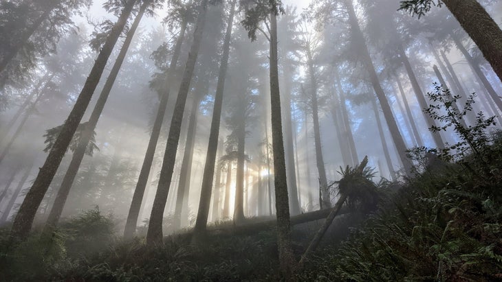
As we climbed back into the forest, the clouds thinned, and shafts of light began to glow through the mist and illuminate the understory. It was Hallelujah Chorus light, the kind of sunbeams you’d expect to see trained on a saint in some medieval painting. After spending hours trudging through the damp brush, the dry warmth was a welcome change.
Near the crest of the mountain, the trees finally broke, and for the first time all day, we could see the clear, blue sky. Below us, the cloud layer stretched as far as we could see, covering everything to the horizon like a second ocean. I snapped another picture, and both of us spent a long moment taking it all in. Then, we started our descent toward Manzanita, back down into the drizzle and the fog.
Four days of tidepooling and whale-watching later, I was ready to stretch my legs again. After an early breakfast at our site in the Forest Service’s Tilicum Beach campground, my wife, Nat, settled in with a book while I threw snacks, water, and extra layers in a daypack and began following the shoreline south with Rhys.
It was just past low tide, cool and foggy again, and the damp sand made for easy going. We took it slowly, stopping to check out the flotsam the waves had carried in, like skate egg cases and driftwood. Rhys found and dragged a long strand of bull kelp after us, leaving a track in the sand. At one point, I spotted movement in the waves and turned to find a pair of sea lions swimming through the surf alongside us.
A staircase and a tunnel carved into the overgrown bushes brought us into Yachats, a town of about 1,000 people hugging the edge of a river mouth. The trail passed through neat residential neighborhoods and a small downtown on marked sidewalks and dirt paths. Maybe it was because we were hiking on a drizzly weekday morning, but it seemed nearly deserted, apart from a few seaside dog walkers and a lone fisherman casting into the surf.
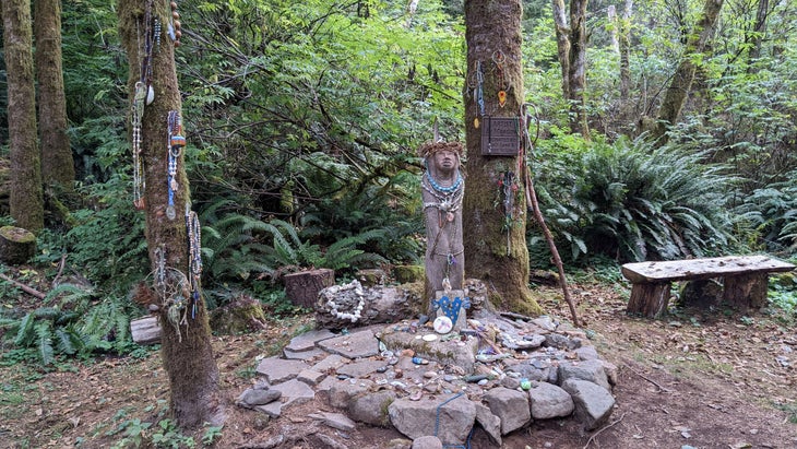
Just past town, where the trail began to climb into the forest once again, we came across an amphitheater cut into the trees. Rows of benches clustered around a small, flat clearing; on the far side of the clearing, a wooden suspension bridge over a now-dry creek led further into the mountains. At the center, draped in beads and stone necklaces, sat a stylized concrete statue of a woman, her face turned to the sky. Her name was Amanda De-Cuys, this 3.7-mile stretch of the OCT—dubbed Amanda’s Trail—was her namesake. As a nearby historical sign informed us, her story was emblematic of one of the darkest chapters in Oregon’s history.
In 1855, the United States government established the Coast Reservation, a 1.1-million-acre parcel spanning one-third of the current state of Oregon’s shoreline. A number of central and southern Oregon tribes, including the Coos, Alsea, Lower Umpqua, and Siuslaw, signed a treaty with the U.S. agreeing to live on the reservation and allow settlement of their homelands in exchange for food, clothing, and other benefits.
If you have the barest grasp of American history, then you can guess what happened next. The U.S. government never ratified the treaty and never provided the supplies or aid it had promised, but took the tribes’ land anyway. Over the next two decades, the U.S. split and shrank the reservation again and again, giving away the best farmland to settlers. In 1860, soldiers forcibly marched tribal members to the Alsea Subagency in what’s now Yachats. Unable to hunt or farm the poor land, half of the subagency’s Native residents would die over the following 17 years, falling victim to hunger, disease, or the brutality of the soldiers sent to keep them in line.
Against that backdrop in 1864, a small U.S. army detachment traveled up the Coos River, just down the coast from Yachats, to round up members of the Coos tribe who had refused to move to the subagency. At a ranch owned by a settler named De-Cuys, the soldiers captured three people, including De-Cuys’s common-law wife, Amanda. In his diary, one of the soldiers, Corporal Royal Bensell, described her as “old and blind”. (De-Cuys, it’s worth noting, could have saved Amanda from captivity by marrying her; he refused.)
“After getting in the boat I was surprised to hear one of the [women ask] me, ‘Nika tika nanage nika tenas Julia [Let me see my little Julia],’” Bensell wrote. “I complied with this parental demand and was shocked to see this little girl throw her arms about old Amanda De-Cuys’s neck and cry, ‘Clihime Ma Ma [dear mama].’”
Being separated from her daughter was only the beginning of Amanda’s troubles. Over the next nine days, Bensell and his comrades marched her and nearly four dozen other Native captives up the coast. Amanda, unable to see, often lagged behind. At one point she tore her bare feet so badly on the rock, Bensell wrote, that she left “blood sufficient to track her by.” There’s no record of Amanda after she reached Yachats; we can only guess as to what the rest of her life, short or long, was like.
Separated from her child and marched at gunpoint to a place she didn’t know—Amanda De-Cuys’s story seems unimaginable in its cruelty. But unimaginable is a poor word to describe something that didn’t just happen, but happened again and again. Today, the Siletz Reservation, which succeeded the Coast Reservation, covers just 0.3 percent of the land it originally did. The violence that Amanda and her contemporaries suffered wasn’t just real, it was foundational: Those land grabs were the basis of the U.S. state of Oregon and everything built there since, from the highways to the national forests to the little towns that stud the coast. After a while at Amanda’s statue, we continued on across the bridge. Rhys sang to himself as he looked down at the dry creek bed below; I followed silently, distracted by my thoughts.
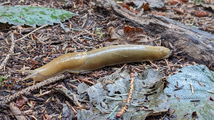
The trail kept climbing, through Jurassic ferns and trees hundreds of years old. Compared to Neahkahnie, it was easy going: the route ascended gradually, tracing ridges and hillsides. The rooty, rough conditions we had encountered earlier were gone, replaced now by even, cruiser treadpath matted with pine needles. With only a few miles left to go and hours of daylight left, Rhys and I stopped for every promising distraction, looking at dew-covered orb weavers’ webs and watching fat banana slugs mosey across the forest floor.
We passed and stopped to greet a few fellow hikers, an older couple out for a dayhike and an OCT thru-hiker with a closed-cell foam mat strapped to the outside of his frameless pack. It was only afterward that I realized why those encounters felt so strange: Until then, we had been hiking almost completely by ourselves. Over the course of two days on the OCT, we had encountered fewer than a half-dozen other hikers, mostly clustered around trailheads and road access.
I understand why the Oregon Coast Trail is the dark horse of long trails. It doesn’t have the wildness of the Pacific Crest Trail or the community of the Appalachian Trail. There’s little backcountry camping, and the trail rarely strays more than a few miles from a paved highway as the crow flies. While the roadwalks are getting shorter, they’re still substantial.
But listen: The OCT has something no other long trail has. It sits on one of the most beautiful coasts in the world, and a hike down it is a chance to get to know every spectacular inch—the tidepools, the ancient forests, the whales sounding offshore, and the people who call it home. It’s the kind of environment that seems to be begging you to go slower, just to soak it all in.
After another hour and a half, we reached the West Shelter, a small three-walled stone shack set up on the top of a sea cliff. When the weather’s clear, it’s the best spot to see Cape Perpetua, a high, wooded headland projecting into the ocean. No such luck: The fog was so thick it was almost corporeal. Rhys and I ate the last of our trail snacks and gazed out into what looked like a wall of swirling cotton.
Still, I didn’t sweat it. On the Oregon Coast Trail, the best view of your life is always just around the corner.